私の研究について
ここでは、私がこれまでに取り組んできた研究を簡単にご紹介します。お読みになりたい項目をクリックすれば、各項目の行の先頭へ飛ぶことができます。
1.人はどうやって地理情報をやりとりしているのか
一つ目にご紹介するのは、主に大学院の修士課程にいた頃に着想し、私の研究者としての出発点になったテーマです。人の地理情報伝達に及ぼす文化や社会の影響は、果たしてどのくらい大きいのか明らかにすることを目的としています。
私たちは日々の暮らしの中で、すんなり地図を読み、カーナビの音声案内を聞いて道順を理解したりしています。よく考えると、これは凄い情報処理能力です。紙に書かれた絵を見、言葉を聞いただけで、目の前に伸びる道をどう進んで遥かかなたのゴールへ辿りつけば良いのかが分かるのですから。しかもリアルタイムでそれができるなんて。最先端のロボットだって、これをスムースにこなそうと思ったら大変でしょう。
こんな高度な情報処理や行動が可能なのは、説明する側とそれを聞く側との間に、地理情報伝達の決まりごとに関する、相互了解が成立しているからです。その相互了解とは、一体どのようなものでしょうか?また、どこからどこまでが生まれつき備わっていて、どこからどこまでが成長の過程で培われてゆくのでしょうか?この疑問を解き明かすための研究です。
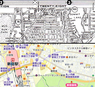
もともと、この研究を思いついたのは、アメリカの大学院に留学していた頃の経験がきっかけです。現地で目にした地図のほとんどが、右図(上半分)のようなものだったのです。ご覧のように、道路網と通りの名前以外、ほとんど何の情報もありません。色も白黒。私にはどう考えても見にくいとしか思えなかったのですが、彼らはこの地図を当たり前のように使っていたのです。逆に私の示した下の地図を「ごちゃごちゃしてて見にくい」と言い出すアメリカ人に、びっくりしました。どうみても、私たちが普段使いこなしている地図のほうが情報量も多く、デザイン的にも優れているように感じませんか?「アメリカは先進国、何でも日本と同じかそれより進んでいる」、そんな私の素朴な先入観に疑問符が付きました。
言葉だって、日本語や英語の別があり、一度日本語ネイティブになってしまえば、容易に英語を話せるようにはなりません。逆も然りです。地図だって同じなんじゃないか、とその時思いました。こんなみすぼらしい地図(失敬!)を当たり前のように使って生きてきた彼らと、私たちとでは、空間理解の仕方そのものが違うのではないか・・と考えるようになりました。
調べてみると、この疑問をちゃんと調べた研究者はほとんど皆無であることも分かってきました。というのも、関連する研究成果の大半は、心理学の人たちが挙げていたのです。それらの文献を読み進めるうち、彼らはもっぱら「人の心=個人」の能力差や、脳内の情報処理を効率化するノウハウ(Strategy: 方略といいます)に目が向いており、個人差の後ろへ広大に横たわる社会や文化の影響なんて、大して重要ではないと思っていることが分かってきました。そこで私は、異文化比較の視点から、地図や道案内文の内容を異文化間で比較分析したり、異なる文化圏の人を経路探索させる(=資料の指示に従って道を辿らせる)比較実験を行うことを通じて、何とか科学的に「地図や道案内表現を用いた空間理解や経路探索に文化の差がある」ことを示そうと考えました。
以下は、この研究について書いた論文の一例です。興味をお持ちの方は読んでみてください。今やこのテーマで論文を書くことはめっきり少なくなりましたが、2024年にはいわゆる「青信号」を例に、色覚認知の文化的差異について久しぶりに論文を書きました。
このテーマに関する研究成果
- 鈴木晃志郎. 2000. 地図化能力の発達に関する一考察-生まれ持つのか,習得するのか-. 人文地理52(4): 65-79.
- Suzuki, K. and Wakabayashi, Y. 2005. Cultural differences of spatial descriptions in tourist guidebooks. In C.Freksa, B.Nedel, M.Knauff and B.Krieg-Brückner (eds.) Spatial cognition IV, LNAI 3343. Springer-Verlag, Berlin: 147-164.
- Suzuki, K. 2013. A cross-cultural comparison of human wayfinding behavior using maps and written directions. Geographical Review of Japan Ser. B 85(2): 74-83.
- Suzuki, K. 2024. Grue-type errors on traffic light colour-name responses. Geographical Reports of Tokyo Metropolitan University 59: 81-88.
2.人はなぜ争うのか。紛争をどう対話・相互理解・和解へと導けるのか
2つめのテーマは、私が大学教員になって初めて取り組んだ地域調査を通じて少しずつ具体化してきた研究課題です。地域住民の意志は、地域社会、外部有識者や一般世論とどのように関わりあい、いかなる過程を経て形づくられていくのかを突き止め、尖鋭化したコミュニティの葛藤や対立は、どうすれば対話・理解、和解へと向かうのかを明らかにしようとしています。
『となりのトトロ』や『千と千尋の神隠し』で有名な宮崎駿 監督が、『崖の上のポニョ』を制作するにあたって二ヶ月ほど滞在し、構想を練ったとされる海辺の港町・・それが福山市鞆町、通称「鞆の浦(とものうら)」です。
鞆の浦は、万葉集にも記述がある、歴史の古い天然の良港です。瀬戸内の海運拠点として栄え、一時は城下町にもなりました。今も往時を物語る名所旧跡や、小ぶりながら素晴らしい木造家屋の街並みが残されています。しかしながらその反面、町内を走る道路は江戸時代そのままの狭さ。元が城下町ですから、外敵からの防衛を目的に、道は入り組んだ形で張り巡らされています。
車社会の到来とともに、その狭い道路を抜けて福山市内へとマイカー通勤する人々や観光客たちの車によって、朝夕には渋滞と駐車違反が発生するようになりました。また道路沿いの住宅では、騒音や振動、排気ガスに悩まされるようになったのです。救急・消防車は延着するかも知れず、狭い一本道では交通を遮断しての下水管の埋設工事もできない。住民の大半はいまだに汲み取り式のトイレを使用しています。
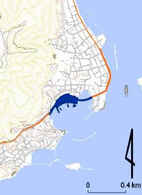
この状況下で行政から提案されたのが、スペースに余裕のある港湾部を埋め立てて幅員の広い道路を通し、ついでに駐車場を作ろうという道路橋計画でした。1983年のことです(=右の地図中央の青い部分)。すでに鞆港を挟んだ両岸まで延びてきている道幅の広い県道(オレンジ部分)が、架橋によって最終的に結ばれ、渋滞が解消されるというアイデアでした。ですから、架橋事業を支持する人たちは口々にこう言います。「アンタ言葉使いからして間違っとるわ。“港湾架橋問題”なんて無い。あれは“港湾整備事業”・・」と。
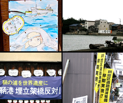
ところが、この計画が公表されると、反対の声を挙げる人々が出てきました。鞆の浦は古き良き江戸の街並みが多くその姿をとどめ、土木建築学的にも貴重な港湾施設遺構が残る美観地区としての側面もあったのでした。もし架橋計画が実施されれば、港湾都市として栄えた鞆の【総体としての景観の調和】は致命的なダメージを被ってしまう・・反対の声を挙げた人々はそう主張しました(写真参照)。「景観権」をとるか「生活権」をとるか。鞆町に長い長い対立の時代が訪れることになります。
一般に、このように公共事業を巡って地域内に対立が起きている場合、行政や企業は悪玉とみなされがちです。か弱い無辜の民たちは、有識者や文化人とスクラムを組んで市民運動を起こし、ついには巨大な悪に勝利する・・という構図が定石でしょう。鞆にも2000年頃を境に、首都圏から高名な建築・土木工学の専門家が訪れ、街並み景観や港湾施設遺構の価値を裏づける調査を実施し、それをもとに架橋事業への批判を展開しました。実は私も、最初に新聞報道や書籍、テレビを通じて鞆の架橋問題を知ったときは、この構図が頭にありました。
・・ところが、観光目的で初めて鞆の浦を訪れ、たまたま入った一軒のお店で立ち話をしているとき、地元の方の口から出てくる言葉が、どうも外で聞いていたのとは違うことに気が付いたのです。海中に異物を建造する事に対して心中複雑ながらも、「橋は必要だから、架けて欲しい」、「渋滞や排気ガスは毎日の生活を脅かす問題」、「住んだ者でなければこの不快さは分からない」、「鞆の住民はみんなそう思っている」・・
彼らから語られる生の声は全くの予想外。私は大いに戸惑いました。マスコミなどを通じて聞こえてくる大きい声だけではなく、生活の現場にいる側の小さな声をも丁寧に拾い、双方の言い分に耳を傾けなければいけない、価値判断の手助けになるようなデータを中立の立場で誰かが作り直す必要があるのではないか・・私はそう考えるようになりました。それがこのプロジェクトを始めるきっかけになりました。
景観を守れ!と言うのはとても簡単。しかし、「実際に暮らしてもいないくせに・・」と頑なになる住民の気持ちも、我々外部の者には無視できない重みがあります。観光地として成長しようとしている鞆の浦は、今後どのようにすればうまくやっていけるのでしょうか。こじれてしまったかに見える住民間の対立は、どうすれば和解や相互理解へと繋がっていくのでしょうか。大きなチャレンジであり、課題です。
当初、鞆の浦の地域的課題についての実証研究から始まったこの研究は、やがて反対派の正当性を裏づけていた世界遺産の「顕著で普遍的な価値」理念や、対立する派閥がお互いを排除する行動原理としてのNIMBY概念など、紛争の背後に横たわるメカニズムに関する研究へと進んでいます。2015年には、山梨県北杜市に進出したメガソーラーをめぐって地域内に生じた景観紛争をとりあげ、電子ジャーナルに紛争当事者を呼んできて誌上で「熟議型民主主義」を実践することにより、予防的に紛争解決を働きかける試みにも挑戦しました。
このテーマに関する研究成果
- 鈴木晃志郎・鈴木玉緒・鈴木 広 2008. 景観保全か地域開発か: 鞆の浦港湾架橋問題をめぐる住民運動. 観光科学研究1: 50-68.
- 鈴木晃志郎 2010. ポリティクスとしての世界遺産. 観光科学研究3: 57-69.
- 鈴木晃志郎 2010. 観光案内図の範域と地物からみた鞆の浦の観光圏. 地理情報システム学会講演論文集19 (CD-ROM).
- 鈴木晃志郎 2011. NIMBY研究の動向と課題. 日本観光研究学会全国大会研究発表論文集26: 17-20.
- 鈴木晃志郎 2014. 住民意識にみる公共事業効果の「神話」性とその構成要因-鞆の浦港湾架橋問題に関するアンケート調査結果を用いて-. 歴史地理学56(1): 1-20.
- 鈴木晃志郎 2015. ユネスコの追加勧告にみる富士山の世界文化遺産としての課題. 地学雑誌 124(6): 995-1014.
- 鈴木晃志郎 2015. NIMBYから考える「迷惑施設」. 都市問題 106(7): 4-11.
- 鈴木晃志郎 2016. 公器としての機関リポジトリ:電子ジャーナルを用いた社会貢献への挑戦. 地球惑星科学連合2016年大会予稿集G-03-23(電子出版:招待講演論文).
- 鈴木晃志郎 2024. NIMBYとは? 発生のメカニズムや解決方法を具体例とともに解説. 朝日新聞 SDGs Action! https://www.asahi.com/sdgs/article/15365606
研究助成
- 鈴木晃志郎 2008.「開発=保全」問題に直面したコミュニティにおける住民意志決定のメカニズム 科研費 若手(B) https://kaken.nii.ac.jp/ja/grant/KAKENHI-PROJECT-20700673/
3.情報技術革新は社会にどのような影響をもたらすのか
最後にご紹介するのは、現在新たに進めつつあるいくつかの理論・実証研究についてです。研究の根幹にあるのは、ここ最近の急速な情報技術革新が社会に与える多方面の影響を、各々の切り口から捉えようとする問題意識で、今のところ大きく以下のような側面から研究を進めています。
3-1 「マッピングの民主化」の可能性と課題についての研究
2010年代に入り、通信速度の飛躍的向上や携帯端末の高性能化、GeoAPIによりリアルタイムに地図を介したコミュニケーションの可能性が広がりました。歴史上、一握りの権力者や製図家が長くそのノウハウや発行権を専有してきた地図が、かつてないスピードで「民主化」されつつあるのが今日の地図利用をめぐる変化といえるでしょう。
地理学者の一人として、私は地図を利用しものごとを可視化する営為に取り組んできました。そんな人間が、これほどドラスティックな変化を目の前にして何ひとつ意見表明をせず発言しないままで良いのか?そう考えるようになり、私なりのやり方でこの状況変化がもつ社会的、哲学的あるいは歴史的意味を考えるようになりました。
興味を持って調べてみると、私がこの研究に取り組み始めた2012年当時、VGIをめぐる議論の多くは、VGIを「地図化する行為(=マッピング)の民主化」としてむしろ歓迎していることが分かってきました。企業や行政が隠しているデータを暴いたり、権力の横暴を告発したり、プライバシーの管轄権を市民の側に取り戻したり、などです。
ただ、行政や企業には職業倫理や法制度の縛りがありますから、仮にその行為が法や倫理に違反していれば処罰・糾弾されますし、その権力を担う者は、然るべく倫理教育を受けて自覚や知識を身につけさせられるはずです。長い年月をかけて積み上げてきた、一定の権力と義務・倫理のトレードオフ関係が成り立っていると考えられます。
しかし、マッピングが民主化されればどうでしょうか?テクノロジーの力を借りて地図化する力を企業や行政のように持ちながら、公の倫理は通用しない。そうした人々による、非倫理的行為のリスクや影響は増大するでしょう。私はこうした課題を問題提起し、「マッピングの民主化」時代に見合った情報倫理を考える必要性を訴えてきました。内容的に、国際的な議論の喚起に主眼があるため英語文献が多くなっていますが、若干日本語で読める成果もあります。
このテーマに関する研究成果
- 鈴木晃志郎 2015. Web 2.0時代の地理学と「電子地理情報倫理」. 地理 60(1): 48-51.
- 鈴木晃志郎 2017. 地理空間情報の倫理. In 若林芳樹・今井 修・瀬戸寿一・西村雄一郎編著『参加型GISの理論と応用』古今書院: 44-50.
- 鈴木晃志郎 2021. ボランタリーな地理情報(VGI)の可能性と課題 ―COVID-19をめぐって―. In 富山大学人文学部『人文学部叢書IV』出版委員会編『人文知のカレイドスコープIV』桂書房: 74-85.
- Suzuki, K. 2018. A newly emerging ethical problem in PGIS - Ubiquitous atoque absconditus and casual offenders for pleasure. In Grueau, C., Laurini, L. and Ragia, L. eds. GISTAM 2018 - Proceedings of the 4th International Conference on Geographical Information Systems Theory, Applications and Management. Science and Technology Publications Press: 22-27.
- Suzuki, K. 2019. Emergence of geovigilantes and geographic information ethics in the web 2.0 era. In Grueau, C., Laurini, R.and Ragia, L. eds. Communications in Computer and Information Science 1061. Springer-Nature AG, Switzerland: 55-72.
- Suzuki, K. 2019. Caveat emptor: A new form of participatory mapping and its ethical implication on PGIS. Proceedings in Cartography and GIScience of the International Cartographic Association 2-126.
- Suzuki, K. 2021. #Purge: Geovigilantism and geographic information ethics for connective action. GeoJournal 86(1): 445-453. https://doi.org/10.1007/s10708-019-10081-7
- Suzuki, K. 2021. Civic-Tech and Volunteered Geographic Information under the COVID-19 Pandemic: A Japanese Case Study. In Grueau, C., Laurini, L. and Ragia, L. eds. GISTAM 2021 - Proceedings of the 7th International Conference on Geographical Information Systems Theory, Applications and Management. Science and Technology Publications Press: 214-221.
- Suzuki, K. 2022. A north-south problem in civic-tech and volunteered geographic information as countermeasures of COVID-19: A brief overview. SN Computer Science 3(5-396). https://doi.org/10.1007/s42979-022-01262-2
- Suzuki, K. 2022. Stigmatization on the Web: Ethical consideration of geospatial stigmatization via online mapping. In Wakabayashi, Y. and Morita, T. eds. Ubiquitous mapping: Perspectives from Japan. Springer Nature Singapore Pte Ltd: 129-142.
研究助成
- 鈴木晃志郎 2020.「デジタル・マッピング時代の地理情報倫理の構築に向けた学際的基礎研究」科学費・基盤(C) https://kaken.nii.ac.jp/ja/grant/KAKENHI-PROJECT-20K01173/
3-2 コロナ禍が促進したeツーリズムの可能性と課題についての研究
新型コロナウイルス感染症(COVID‑19)の影響が世界的に長期化するなか、特に深刻な影響を被ったのが対面接触を前提に成立してきた観光業でした。この危機を乗り越え、社会経済活動としての観光業の持続的発展を考える上での打開策として注目されているのが「eツーリズム」です。
eツーリズムの概念は1990年代にすでに成立しており、ネット・マーケティングやeコマースなど、対面接触を前提としたうえでその手続きの一部を電子化することで合理化することを指す言葉として用いられ始めました。コロナ禍は、IT革新を反映し商用化の道が拓かれつつあったXR(リアルとバーチャルの情報を融合させ、結果を人の五感へとフィードバックさせる技術)を巻き込みながら、観光研究に新しい可能性や課題をもたらしつつあります。
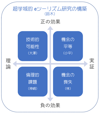
そこで私は、eツーリズムの新たな課題を、①観光体験が代替されることによる観光地側の機会喪失と、利用者側の機会拡大の2つの側面から捉え、工学や倫理学、地域研究や社会福祉分野の研究者と共同で、eツーリズムをロータッチエコノミーの文脈下の「行かない観光」を含むものとして再定義し、ポスト・コロナの社会的状況を反映したeツーリズム研究の新たな領野を切り開こうとしています。この研究は以下の科研費の助成を得て始められたばかりでまだ発展途上ですが、成果の一部として以下の論文を公表しました。今後徐々に研究成果が公になる予定です。
このテーマに関する研究成果
- 鈴木晃志郎・松井陽史 2023. ユーザー生成コンテンツを活用した日本人と外国人の観光行動分析 ―世界文化遺産の村、白川郷を事例に―. 日本観光学会誌 64: 1-12.
研究助成
- 鈴木晃志郎 2023. eツーリズムにおけるXRの可能性と課題、機会の喪失と平等に関する超学域的研究. 科研費・基盤(C) https://kaken.nii.ac.jp/grant/KAKENHI-PROJECT-23K11645/
3-3 怪異に与えられた社会的役割に関する研究
怪異(お化けやその出現場所である心霊スポット)は、洋の東西、時代のいかんを問わず広く受け入れられた社会的関心事です。なのに、科学者としては「お化けなんて論ずるに値しません」と冷たく言い放ち、まともに相手にしない風を装わなければいけない、なかなかにアンビバレントな存在です。試みに国内でお化けを真面目に研究している、まともな(←ここが重要)科学者を探してみてください。民俗学を除いてほとんどいないはずです。しかし、科学コミュニティにおいてお化けがキワモノ化したのは、実のところたった100年前(1910年)のことです。お化けを科学していけない理由なんて、実のところ多くの科学者は真面目に考えていないのでは?
ということで、適切なアプローチと方法さえとれば、お化けだって立派に科学になると証明すべく、以前当方の大学院に在籍していた院生と始めたのが「お化けの地理学」でした。一見、情報技術革新とは無関係そうですが、この研究はコンピュータによる空間解析が可能になったことで実現した側面があります。
このテーマの説明に関しては、以前請われて大学のウェブサイトに寄稿したおあつらえ向きの原稿があるので、これを転載しておきましょう。これから大学への進学を考えている高校生の皆さん、ぜひ読んでみてください。
「私の専門は地理学です」
そう聞いて、地理A、地理Bの教科書が皆さんの脳裏を過ぎるのは至極ごもっとも。「雨温図みて何気候か分かる人ですよね?」、「スリランカの首都がコロンボかスリジャヤワルダナプラコッテかが分かる人ですよね?」―学問としての地理学の認識は、そんなところではないでしょうか。しかし、地理学は皆さんが考えているよりも、はるかに自由な学問分野です。何しろ対象の制約はたった1つ。「地表上に、何らかの空間的な広がりをもつ現象」だけなのですから。
物を買ってお金を払う。そのときお金は交換を通じて人の手から手へと渡り、世界を行き来します。こう考えれば経済活動は地理学の対象ですね(経済地理学)。あなたの今日一日の生活パターンもそう。24時間の中であちこち行動したでしょう(時間地理学)。え?部屋から一歩も出なかった?だとしてもあなたに「部屋からみて学校はどっちにありますか?」と聞いたら、視野に学校が入ってなくても学校の方位や距離はうすうす分かるでしょう?それはどうして?そのメカニズムを研究すればこれも地理学(行動地理学)。地理学は、実のところこの世の中のほとんど全ての現象を守備範囲に収めているのです。
「じゃあ、お化けは地理学にできますか?」
では、お化けという、およそ学問とは無縁そうな題材ならどうでしょうか。実は地理学なら、お化けすらも学問にすることができます。ここで、私が大学院の指導学生と一緒に行った研究を少しご紹介することにしましょう。
1910年、日本は史上空前のオカルトブームのただ中にありました。旧帝大の教授2人が、遠隔透視能力をもつと自称していた女性を相手に大まじめの透視実験をやったのがこの年なのです(千里眼騒動)。
富山県内の2つの地方紙もこのオカルトブームに乗り、県内の怪談話を収集して連載記事を企画しました。この怪談話には、誰がどこで、どんなお化けにあったかが説明されています。この怪談話を地図上に落としたらどうなるでしょう?ほら、「地表上に、何らかの空間的な広がりをもつ現象」になりませんか?私と私の指導学生だった于さんはこのようにして、今から100年前(大正時代)の新聞に載っている怪談の中から、出たお化けの種類とその位置情報を抽出しました。同じように現代の怪談話を、ウェブ上の心霊サイトやSNSのログから抽出。100年の時を経て、お化けの出没地点がどのように時代変化し、出てくるお化けがどのように変容し、怪談の語り口がどう変化したのかを、科学的に比較することを試みたのです。
お化けも地理学になる
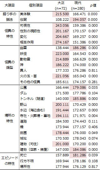
表1は、各々の怪談の中にお化けや怪奇現象(=怪異)が出てきたときに1、出てこなかった時に0とカウントする方法で、100年前と現代の怪談の内容を数学的に比較分析した結果です。p値が0.05未満の項目は、大正時代と現代の怪談の間に有意差=偶然では片づけることのできない、数学的に意味のある差が存在していることを示します。
「語り手の話法」からは、大正時代の怪談は直接経験の形で語られ、現代の怪談は不確かなうわさの形を取る傾向があることが分かります。同じように「怪異の特性」からは、大正時代には目に見えていた怪異が見えない存在になっていったことが分かりますし、「怪異の類型」からは、大正時代の怪異は種類も豊富であったことが分かります。現代群の値が有意に高かったのは「幽霊」だけでした。つまり、現代の怪異は画一化され、目にも見えない存在になっているのです。
怪異にまつわる場所に違いはあるでしょうか。「場所の特性」は、怪異の報告された場所を種類別に分類して、大正と現代の有意差を検討したものです。大正群は現代に比して、野山や水辺、田圃のほか、火葬場や墓地、寺社などの生活圏の周辺が選ばれていることが分かります。でも、現代のそれは廃墟とトンネルだけ。大正時代は居宅にもあらわれた怪異は、現代は人里離れた空き家や廃墟、トンネルでしか遭えない存在になってしまったというわけです。
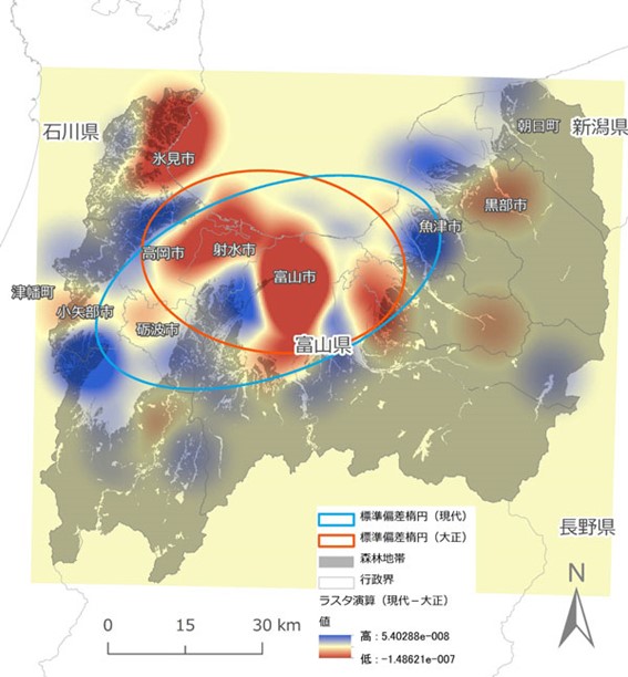
大正時代は今よりも、怪異がずっと身近な存在だった―これを出没地点の違いから見たのが図1です。個々の怪談の文章を丁寧に読み、その中から出没地点を特定する手掛かりを探します。出没した場所さえ特定できれば、コンピュータの中にその位置情報を取り込み、大正時代の分布パターンと現代の分布パターンの「空間的な引き算」処理を行うことによって、富山県内のどの辺りに、大正と現代の怪異がより現れやすいか、を可視化することができます(ラスタ演算といいます)。色が赤に近いところほど、現代と比べて大正時代の怪異がより現れやすく、青に近いほど現代の怪異が大正のそれに比して現れやすい場所であることを意味します。ちなみに、グレーの部分は森林地帯。どうですか?青のエリアは、ほとんどが森林地帯だと思いません?この分析からも、現代のお化けが市街地の生息場所を追われ、急速に山間部へと引っ込んでいっている様子が分かるのです。存在するなんて口にしたら笑われそうなお化け、人のうわさ話にすぎないものでも、工夫ひとつで科学になるのです。
勉強と学問は違います
高校生の皆さん、受験に向けて大変な日々をお過ごしでしょう。苦しい受験を克服した先に薔薇色の学生生活が待っていることを夢見て、懸命に勉強に勤しんでいることと思います。でも、皆さんが今している勉強は、学問ではないのです。
皆さんが覚えているのは正解でしょう。問題を解くのは正解にたどり着くためですよね?でも、その正解を最初に見つけたのは誰?そう、皆さんではないのです。
大学で皆さんに求められるもの、それは人が作った正解を覚える消費者としてのあなたではなく、新しい正解を生み出す知的生産者としてのあなたです。ふざけているように見えるお化けの研究も、これまで誰も試みなかった方法で、お化けを分析できるという発見をしたから、学術誌に掲載されました。次はあなたの番です。大学はあなたが新しい正解を探すためにある場所です。
あなたの求める正解が、地理学の守備範囲と交錯していたら―そのときはキャンパスの中で、お会いしましょう。
(出典:見えない「お化け」を可視化する https://www.u-toyama.ac.jp/future/ksuzuki_01/)
このテーマに関する研究成果
- 鈴木晃志郎・于 燕楠 2020. 怪異の類型と分布の時代変化に関する定量的分析の試み. E-Journal GEO 15(1): 55-73.
- 鈴木晃志郎 2021. さまざまな地図を用いた地域の見方・考え方. In 菊地俊夫編著『地の理の学び方』二宮書店: 118-125.
- 鈴木晃志郎 2022. 地理学で読み解く『呪怨』と「恐怖の村」. ユリイカ 54(11): 215-221.
- Suzuki, K., Ito, S. and U, Y. 2023. Quantitative analyses of the geospatial characteristics of haunted sites using open data. Social Sciences & Humanities Open 8(1): 100701. https://doi.org/10.1016/j.ssaho.2023.100701
その他のテーマ
このほか、これまでに取り組んだ研究として:
- 1.メディア誘発型観光(Media-induced tourism)のあり方についての研究
- 2.放置竹林の拡大メカニズムの解明と,その抑止策の検討
- 3.リージョナリズムと近代フランス音楽の展開
- 4.アーリ「新たな移動論パラダイム」の批判的検討
・・などについても,研究や執筆活動をしています。
About My Research
Here, I offer you a brief introduction to the research I have pursued over the years. By clicking on any of the items below, you can jump directly to the beginning of the corresponding section.
1. How do people communicate geographic information?
The first topic I would like to introduce is the one that came to me mainly during my time in a master’s program at graduate school, and which became the starting point of my life as a researcher. The aim of this research is to clarify how strongly culture and society influence the ways in which people convey and understand geographic information.
In our everyday lives, we read maps with ease and listen to spoken directions from car navigation systems to grasp a route. When you stop to think about it, this is quite a remarkable feat of information processing. Simply by looking at drawings on paper and listening to words, we are able to understand how to proceed along the roads in front of us and eventually reach a destination far away. And we can do all of this in real time. Even the most advanced robots would struggle to perform this smoothly!
Such sophisticated processing and behavior are possible because there is a shared understanding between the person giving directions and the person receiving them—an implicit set of conventions about how geographic information is communicated. But what exactly does this shared understanding consist of? Which parts of it are innate, and which parts are cultivated through growth and experience? This research seeks to shed light on these questions.
The original inspiration for this work came from my time studying at a graduate school in the United States. Most of the maps I encountered there looked like the one shown on the right (upper half). As you can see, they contain little information beyond the road network and street names. They are largely black and white. To me, they seemed plainly hard to read, yet people there used them as a matter of course. On the other hand, I was taken aback when some Americans described the map I showed them (the one below) as “cluttered” and “difficult to read.” To my eyes, the maps we commonly use in Japan appear richer in information and more refined in design. Don’t they seem that way to you as well? This experience made me question my simple assumption that “the United States is a highly advanced country, so everything must be the same as, or more advanced than, Japan.”
Languages, after all, differ—Japanese and English, for instance. Once we grow up as native speakers of Japanese, we do not easily become fluent English speakers, and the reverse is equally true. I began to wonder whether maps might be similar. Having grown up using what struck me as rather austere maps (forgive the bluntness), perhaps people there understand space itself in a different way from us. This thought stayed with me.
As I looked into the existing literature, I discovered that very few researchers had seriously examined this question. Most related studies had been conducted by psychologists. As I read their work, it became clear that their focus was largely on differences in individual ability or on strategies for making information processing in the brain more efficient. The broader influences of society and culture—stretching out behind individual differences—were often regarded as relatively unimportant. In response, I decided to take a cross-cultural perspective. By comparing the content of maps and written directions across cultures, and by conducting comparative experiments in which people from different cultural backgrounds were asked to find routes by following given instructions, I sought to demonstrate scientifically that there are indeed cultural differences in spatial understanding and route-finding when maps and directions are used.
Below is an example of a paper I have written on this topic. If you are interested, I hope you will take a look. While I now write far fewer papers in this area, in 2024 I returned to the theme after some time away, publishing a study on cultural differences in color perception, using the familiar example of the “green traffic light.”
Research Publications on This Topic
- Suzuki, K. 2000. Note on the development of mapping abilities: controversy between nativism and constructivism. Japanese Journal of Human geography 52(4): 385-399 (65-79).
- Suzuki, K. and Wakabayashi, Y. 2005. Cultural differences of spatial descriptions in tourist guidebooks. In C.Freksa, B.Nedel, M.Knauff and B.Krieg-Brückner (eds.) Spatial cognition IV, LNAI 3343. Springer-Verlag, Berlin: 147-164.
- Suzuki, K. 2013. A cross-cultural comparison of human wayfinding behavior using maps and written directions. Geographical Review of Japan Ser. B 85(2): 74-83.
- Suzuki, K. 2024. Grue-type errors on traffic light colour-name responses. Geographical Reports of Tokyo Metropolitan University 59: 81-88.
2. Why do people come into conflict, and how can conflicts be guided toward dialogue, mutual understanding, and reconciliation?
The second theme gradually took shape through regional fieldwork that I began after becoming a university faculty member. This line of research seeks to understand how the will of local residents interacts with the local community, external experts, and broader public opinion, and through what processes it is ultimately formed. At the same time, it asks how sharpened tensions and conflicts within communities might be steered toward dialogue, understanding, and, eventually, reconciliation.
The seaside port town where director Hayao Miyazaki, famed for My Neighbor Totoro and Spirited Away, is said to have stayed for about two months while developing ideas for Ponyo on the Cliff by the Sea is Tomo-no-Ura, in Tomo Town, Fukuyama City.
Tomo-no-Ura is a naturally sheltered harbor with a long history, mentioned even in the Man’yōshū, Japan’s oldest anthology of poetry. It once flourished as a hub of maritime transport in the Seto Inland Sea and at one time developed into a castle town. Even today, many historic sites and a charming streetscape of modest yet beautifully crafted wooden houses bear witness to its past. At the same time, however, the roads running through the town remain as narrow as they were in the Edo period. As a former castle town, its streets were deliberately laid out in a complex, winding pattern for defensive purposes.
With the arrival of an automobile-centered society, these narrow roads began to fill with commuters driving to Fukuyama City and with tourists, leading to traffic congestion and illegal parking during the morning and evening hours. Homes along the roads came to suffer from noise, vibration, and exhaust fumes. Ambulances and fire engines risk delays, and on the single narrow thoroughfare it is impossible even to block traffic in order to carry out sewer construction. As a result, many residents still rely on traditional non-flush toilets.
Against this backdrop, the local authorities proposed a plan to reclaim part of the harbor area—where space was more abundant—to build a wide road and accompanying parking facilities. This was in 1983 (shown as the blue area in the center of the map on the right). The idea was to connect, by means of a bridge, the already widened prefectural roads (shown in orange) extending along both sides of the harbor, thereby easing congestion. For this reason, supporters of the project would often say, with some insistence, “You’re using the wrong words. There is no such thing as a ‘harbor bridge problem.’ This is a ‘harbor improvement project.’”
When the plan was made public, however, voices of opposition soon emerged. Tomo-no-Ura retains much of its traditional Edo-period townscape and is also valued as a scenic area containing historically significant harbor structures from the perspective of civil and architectural engineering. Opponents argued that if the bridge were built, the overall harmony of the landscape that had defined Tomo as a port city would suffer irreparable damage (see photos). Should one prioritize the “right to scenery,” or the “right to everyday life”? Thus began a long, drawn-out period of conflict within the town.
In general, when local conflicts arise over public works projects, governments and corporations are often cast as the villains. The familiar narrative pits vulnerable residents, allied with experts and cultural figures, against a powerful adversary—until, in the end, the citizens prevail. Around the year 2000, Tomo-no-Ura also saw well-known architectural and civil engineering experts arrive from the Tokyo metropolitan area to conduct surveys demonstrating the value of its townscape and harbor remains, using these findings to criticize the bridge project. When I first learned of the Tomo bridge issue through newspapers, books, and television, I too had this familiar storyline in mind.
…Yet when I visited Tomo-no-Ura for the first time as a tourist and happened to strike up a casual conversation in a local shop, I realized that what local residents were saying did not quite match what I had heard from outside. While harbor construction weighed heavily on their minds, many nonetheless said things like, “We need the bridge, so we want it built,” “Traffic congestion and exhaust fumes threaten our daily lives,” “You can’t understand this discomfort unless you live here,” and “All the residents of Tomo feel this way.”
These candid voices were entirely unexpected, and I found myself deeply unsettled. I began to think that it was not enough to listen only to the loud voices amplified by the media. Someone needed to carefully gather the quieter voices of those living with the problem every day, to listen attentively to both sides, and to reconstruct data from a neutral standpoint that could genuinely help people make informed value judgments. This realization became the starting point of this project.
Calling for the protection of the landscape is, in itself, easy enough. Yet the feelings of residents who bristle at being told what to do by those who “do not even live here” carry a weight that we outsiders cannot ignore. As Tomo-no-Ura seeks to grow as a tourist destination, how can it move forward in a way that works for everyone? And how might conflicts between residents, which appear deeply entrenched, be transformed into reconciliation and mutual understanding? These are formidable challenges.
What began as an empirical study of local issues in Tomo-no-Ura has since expanded into research on the mechanisms underlying conflict itself. This includes examination of concepts such as the “Outstanding Universal Value” principle of World Heritage, which was used to support the legitimacy of the opposition, and the notion of NIMBY (“Not In My Backyard”) as a behavioral logic through which opposing groups seek to exclude one another. In 2015, I also took up a landscape conflict surrounding the development of a mega-solar project in Hokuto City, Yamanashi Prefecture. By inviting the parties to the dispute to participate directly in an online journal and practicing “deliberative democracy” within its pages, I experimented with an approach aimed at preventive conflict resolution.
Research Publications on This Topic
- Suzuki, K., Suzuki T. and Suzuki H. 2008. Bridge over the Troubled Harbor - dynamics of local residents' campaign in Tomonoura. The International Journal of Tourism Science 1: 50-68.
- Suzuki, K. 2010c. The world heritage as politics. The International Journal of Tourism Science 3: 57-69.
- Suzuki, K. 2010e. The sights and spheres in the sight-seeing maps of Tomonoura. Proceedings of Geographic Information System Association 19: (CD-ROM, 6p).
- Suzuki, K. 2011b. NIMBY studies: problems and prospects. Proceedings of the Japan Institute of Tourism Research Annual Conference 26: 17-20.
- Suzuki, K. 2014b. Prevalent 'Myths' about the effect of the estimated outcomes of public project in Tomonoura. The Historical Geography 56(1): 1-20.
- Suzuki, K. 2015b. Understanding recommendations to be implemented for the better management of Mt. Fuji as a World Cultural Heritage. Journal of Geography 124(6): 995-1014.
- Suzuki, K. 2015e. Rethinking Locally unwanted land use from NIMBY studies. The Municipal Problems 106(7): 4-11.
- Suzuki, K. 2016a. Maintaining a Repository-based e-Journal as a tool for becoming a COC. Proceedings of the Japan Geoscience Union Meeting 2016: G-03 (Invited Paper).
- Suzuki, K. 2024. What is NIMBY? Mechanisms and solutions explained with concrete examples. Asahi Shimbun SDGs ACTION!. (Last updated: Aug. 5, 2024). https://www.asahi.com/sdgs/article/15365606
Research Grants
- Suzuki, K. 2008. Research grant: JSPS (Grant-in-Aid for Scientific Research: Category Youth-B: Head). The decision-making mechanism of a community facing 'development or conservation' dilemma (No. 20700673). https://kaken.nii.ac.jp/ja/grant/KAKENHI-PROJECT-20700673/
3. How does innovation in information technology affect society?
Finally, I would like to introduce several theoretical and empirical studies that I am currently developing. At the heart of this work lies a concern with the many ways in which the rapid advances in information technology we have seen in recent years are reshaping society. From this perspective, my research presently focuses on the following main aspects.
3-1. Exploring the possibilities and challenges of the “democratization of mapping”
Since the 2010s, dramatic improvements in communication speeds, the growing sophistication of mobile devices, and the spread of GeoAPIs have greatly expanded the possibilities for real-time, map-based communication. Maps—whose know-how and publishing rights were long monopolized by a small number of powerful actors and professional cartographers—are now being “democratized” at an unprecedented pace. This, I believe, captures the essence of recent changes in how maps are created and used.
As a geographer, I have long been engaged in the practice of using maps to visualize various aspects of the world around us. Faced with such a drastic transformation, I began to ask myself whether it was acceptable for someone like me to remain silent and refrain from offering any perspective at all. This led me to reflect, in my own way, on the social, philosophical, and historical significance of these changes.
As I explored the literature, I found that around 2012, when I first began working on this topic, much of the discussion surrounding VGI (Volunteered Geographic Information) was distinctly positive. VGI was often welcomed as a form of “democratization of mapping.” It was seen as a means of uncovering data hidden by corporations or governments, exposing abuses of power, and reclaiming control over privacy from institutional authorities and returning it to citizens.
That said, governments and corporations operate under professional codes of ethics and legal frameworks. If their actions violate laws or ethical standards, they can be sanctioned or publicly criticized, and those who hold power are expected to receive appropriate ethical training and acquire a sense of responsibility. In this way, a certain balance—a trade-off between power on the one hand and duty and ethics on the other—has been built up over many years.
But what happens when mapping itself becomes democratized? Through the aid of technology, individuals may acquire mapping capabilities comparable to those of governments or corporations, while public ethical standards no longer apply in the same way. Under such conditions, the risks and impacts of unethical behavior are likely to increase. By raising these concerns, I have argued for the need to reconsider information ethics suited to an era of democratized mapping. Because this work aims primarily to stimulate international discussion, many of the resulting publications are in English, though a small number are also available in Japanese.
Research Publications on This Topic
- Suzuki, K. 2015c. Geography and electronic geographic information ethics in the Web 2.0 age. Geography 60(1): 48-51.
- Suzuki, K. 2017.a Geospatial information and ethics. In Wakabayashi, Y., Imai, O., Seto, T., and, Nishimura, Y. eds. Theories and Practices in PGIS. Tokyo, Kokon Shoin: 44-50.
- Suzuki, K. 2021c. Civitas in the years of pandemos: The forefront of Voluntary Geographic Information (VGI) over COVID-19. In Editorial Committee of the Collegium of Humane Wisdom, University of Toyama ed. Kaleidoscope of Humane Wisdom IV. Katsura Shobo: 74-85.
- Suzuki, K. 2018. A newly emerging ethical problem in PGIS - Ubiquitous atoque absconditus and casual offenders for pleasure. In Grueau, C., Laurini, L. and Ragia, L. eds. GISTAM 2018 - Proceedings of the 4th International Conference on Geographical Information Systems Theory, Applications and Management. Science and Technology Publications Press: 22-27.
- Suzuki, K. 2019. Emergence of geovigilantes and geographic information ethics in the web 2.0 era. In Grueau, C., Laurini, R.and Ragia, L. eds. Communications in Computer and Information Science 1061. Springer-Nature AG, Switzerland: 55-72.
- Suzuki, K. 2019. Caveat emptor: A new form of participatory mapping and its ethical implication on PGIS. Proceedings in Cartography and GIScience of the International Cartographic Association 2-126.
- Suzuki, K. 2021. #Purge: Geovigilantism and geographic information ethics for connective action. GeoJournal 86(1): 445-453. https://doi.org/10.1007/s10708-019-10081-7
- Suzuki, K. 2021. Civic-Tech and Volunteered Geographic Information under the COVID-19 Pandemic: A Japanese Case Study. In Grueau, C., Laurini, L. and Ragia, L. eds. GISTAM 2021 - Proceedings of the 7th International Conference on Geographical Information Systems Theory, Applications and Management. Science and Technology Publications Press: 214-221.
- Suzuki, K. 2022. A north-south problem in civic-tech and volunteered geographic information as countermeasures of COVID-19: A brief overview. SN Computer Science 3(5-396). https://doi.org/10.1007/s42979-022-01262-2
- Suzuki, K. 2022. Stigmatization on the Web: Ethical consideration of geospatial stigmatization via online mapping. In Wakabayashi, Y. and Morita, T. eds. Ubiquitous mapping: Perspectives from Japan. Springer Nature Singapore Pte Ltd: 129-142.
Research Grants
- Suzuki, K. 2020.Research grant: JSPS (Grant-in-Aid for Scientific Research: Category Main-C: Head). An interdisciplinary study of geographic information ethics for the digital mapping generation (No. 20K01173) https://kaken.nii.ac.jp/ja/grant/KAKENHI-PROJECT-20K01173/
3-2. Exploring the possibilities and challenges of e-tourism accelerated by the COVID-19 pandemic
As the global impact of the COVID-19 pandemic persisted over an extended period, few sectors were hit as hard as tourism, which had long depended on face-to-face interaction. One approach that has attracted growing attention as a way to overcome this crisis and to ensure the sustainable development of tourism as a socio-economic activity is e-tourism.
The concept of e-tourism itself dates back to the 1990s. It was originally used to describe efforts to rationalize tourism-related processes—such as online marketing and e-commerce—by digitizing parts of procedures that still fundamentally presupposed in-person contact. The COVID-19 pandemic, however, has brought new possibilities and challenges to tourism studies, particularly by accelerating the commercialization of XR technologies, which integrate real and virtual information and feed the results back to human sensory experience, reflecting ongoing advances in information technology.
In response, I have sought to reframe the emerging challenges of e-tourism from two complementary perspectives: (1) the potential loss of opportunities for destinations when tourism experiences are substituted, and (2) the expansion of opportunities for users. Working collaboratively with researchers in engineering, ethics, area studies, and social welfare, I am redefining e-tourism to include forms of “tourism without travel” within the context of a low-touch economy. Through this approach, I aim to open up a new field of e-tourism research that reflects the social conditions of the post-COVID era. This research has only just begun, supported by a Grant-in-Aid for Scientific Research, and it remains very much a work in progress. Nevertheless, some of the initial findings have already been published in the form of the papers listed below, and further results will be made public gradually in the years to come.
Research Publications on This Topic
- Suzuki, K. and Matsui, Y. 2023. Comparative Analysis of Japanese and Foreign Tourist Behaviour using User-Generated-Content: A case study of Shirakawa-go, a World Heritage village. Journal of Tourism Research 64: 1-12.
Research Grants
- Suzuki, K. 2023. Research grant: JSPS (Grant-in-Aid for Scientific Research: Category Main-C: Head). Supra-academic research on the potential and challenges of XR in e-tourism, loss of opportunity and equality. (No. 23K11645). https://kaken.nii.ac.jp/grant/KAKENHI-PROJECT-23K11645/
3-3. Research on the social roles assigned to the uncanny things
The uncanny things—ghosts and the so-called haunted places associated with them—has been a subject of widespread social interest across cultures, both East and West, and across historical periods. And yet, as scientists, we are often expected to dismiss such matters with a cool “ghosts are not worth discussing,” maintaining an air of studied indifference. It is, in truth, a deeply ambivalent presence. As an experiment, try looking for researchers in Japan who study ghosts seriously and scientifically—seriously being the key word here—outside of folklore studies. You will likely find almost none. However, the marginalization of ghosts within the scientific community is, in fact, a relatively recent phenomenon, dating back only about a century, to around 1910. Have most scientists really given serious thought to why ghosts should not be considered a legitimate subject of scientific inquiry?
With this in mind, and in order to demonstrate that ghosts, too, can be studied scientifically if approached with appropriate questions and methods, I began a project known as the “Geography of Ghosts” together with a graduate student who was then enrolled in my program. At first glance, this topic may seem unrelated to advances in information technology. Yet the research was made possible in large part by the advent of computer-based spatial analysis.
For a more detailed introduction to this theme, I have on a previous occasion contributed an essay on request to my university’s website that is particularly well suited for this purpose. I will reproduce that piece here. To high school students who are considering applying to university: I very much hope you will give it a read.
“My field of expertise is geography.”
When you hear that, it is perfectly natural for images from your Geography A or Geography B textbooks to flash through your mind. “You’re someone who can tell the climate just by looking at a climograph, right?” “You’re someone who knows whether the capital of Sri Lanka is Colombo or Sri Jayawardenepura Kotte, right?”
That is probably how many people picture geography as an academic discipline. And yet, geography is far freer and more expansive than you might imagine. In fact, it has only one basic requirement: it deals with phenomena that have some form of spatial extent on the Earth’s surface.
When you buy something and pay for it, money passes from hand to hand through exchanges and travels around the world. Seen this way, economic activity is a subject of geography—economic geography. The pattern of your daily life is another example. Over the course of 24 hours, you move about from place to place—this is the realm of time geography. Oh, you didn’t leave your room at all today? Even so, if I asked you, “From your room, which direction is your school?” you would probably have a rough sense of its direction and distance, even if you cannot actually see it. Why is that? Studying the mechanisms behind such everyday spatial understanding is also geography—behavioral geography. In truth, geography encompasses almost everything that happens in our world.
“So… can ghosts be studied in geography?”
What about a topic that seems as far removed from academia as one could imagine—ghosts? As it turns out, geography can even make ghosts a subject of scholarly inquiry. Let me briefly introduce a study that I conducted together with a graduate student I supervised.
In 1910, Japan was in the midst of an unprecedented occult boom. That was the year when two professors from an imperial university carried out a dead-serious experiment in clairvoyance with a woman who claimed to possess such powers—the so-called Senrigan Incident.
Two local newspapers in Toyama Prefecture also rode this wave of occult enthusiasm and launched a serialized project collecting ghost stories from around the prefecture. These stories describe who encountered what kind of ghost, and where. What would happen if we plotted these stories on a map? They would suddenly become “phenomena with spatial extent on the Earth’s surface,” wouldn’t they?
Using this idea, my former graduate student Yu and I extracted information on the types of ghosts and their locations from ghost stories published in newspapers about 100 years ago, during the Taishō era. We then did the same for contemporary ghost stories, drawing on haunted-place websites and social media logs. By comparing these two datasets across a century, we sought to examine scientifically how the locations of ghost sightings have shifted over time, how the kinds of ghosts that appear have changed, and how the narratives themselves have evolved.
Ghosts, too, can be studied through geography
Table 1 presents the results of a quantitative comparison between ghost stories from about 100 years ago and those from the present day. Each episode was coded as 1 when a ghost or supernatural phenomenon (that is, an instance of the uncanny) appeared, and 0 when it did not. Items with p-values below 0.05 indicate statistically significant differences between Taishō-era and contemporary ghost stories—differences that cannot be explained away as mere chance.
Looking first at narrative style, we see that Taishō-era ghost stories tend to be told as accounts of direct personal experience, whereas contemporary stories more often take the form of uncertain rumors. Similarly, in terms of the characteristics of the uncanny, phenomena that were once visible in the Taishō period have gradually become invisible presences in modern times. The category of types of the uncanny also shows that Taishō-era stories featured a much richer variety of entities. In contrast, the only category with a significantly higher value in the contemporary group was “ghosts.” In other words, today’s uncanny has become standardized and largely invisible.
Are there also differences in the places associated with the uncanny? The variable place characteristics classifies the locations where uncanny phenomena were reported and examines differences between the Taishō and contemporary periods. Compared with the present day, Taishō-era stories more often situate such encounters in mountains and fields, near water, in rice paddies, and around the edges of everyday living spaces—such as cremation grounds, cemeteries, temples, and shrines. By contrast, in contemporary stories the locations are almost exclusively abandoned buildings and tunnels. Whereas uncanny phenomena once appeared even within people’s homes, they have now become something one encounters only in deserted houses, ruins, or tunnels far from daily life.
The idea that the uncanny was far more familiar in the Taishō era is illustrated in Figure 1, which focuses on differences in appearance locations. By carefully reading each story and identifying clues that point to where the phenomenon occurred, we can determine its location. Once a location is identified, the positional data can be entered into a computer. By then performing a “spatial subtraction” between the Taishō-era and contemporary distribution patterns—a process known as raster calculation—we can visualize which areas of Toyama Prefecture were more prone to uncanny appearances in each period. Areas shaded closer to red indicate places where the uncanny appeared more frequently in the Taishō era than today, while areas closer to blue indicate the opposite. The gray areas represent forested regions.
What do you think? Don’t the blue areas largely coincide with forests? This analysis, too, suggests that modern ghosts have been driven out of urban spaces and have retreated rapidly into mountainous regions. Even ghosts—things we might hesitate to say exist for fear of being laughed at, or dismiss as mere rumor—can, with a bit of ingenuity, become the subject of scientific inquiry.
Studying and scholarship are not the same
To all high school students: you are probably spending demanding days preparing for your entrance examinations. I imagine you are working hard, dreaming that a rosy student life awaits you once you overcome these trials. But let me say this gently and honestly: what you are doing now is studying, not scholarship.
What you are memorizing now are correct answers. Solving problems, after all, is about arriving at the correct answer, isn’t it? But who discovered those answers in the first place? It wasn’t you.
What will be expected of you at university is not that you remain a consumer who memorizes answers created by others, but that you become an intellectual producer who creates new answers. Even research on ghosts—which may look playful or frivolous at first glance—was published in an academic journal because it discovered a way to analyze ghosts using methods no one had tried before.
Now it is your turn. A university is a place that exists so that you can search for new answers. And if the answers you seek happen to intersect with the broad reach of geography—then let us meet again, somewhere on campus.
(Source: “Visualizing the Invisible ‘Ghosts’”)https://www.u-toyama.ac.jp/future/ksuzuki_01/)
Research Publications on This Topic
- Suzuki, K. and U, Y. 2020. Quantitative analyses of chronological changes in types and spatial patterns of paranormal events. E-Journal Geo 15(1): 55-73.
- Suzuki, K. 2021b. How to see and think regions with maps. In Kikuchi, T. ed. Various visions and thoughts of regions in geography. Tokyo, Ninomiya-Shoten: 118-125.
- Suzuki, K. 2022. 'The Grudge' and the 'Village of Fear' as read through geography. Eureka 54(11): 215-221.
- Suzuki, K., Ito, S. and U, Y. 2023. Quantitative analyses of the geospatial characteristics of haunted sites using open data. Social Sciences & Humanities Open 8(1): 100701. https://doi.org/10.1016/j.ssaho.2023.100701